Agricultural Precision Farming with Satellite and Drone Data
Precision agriculture, based on the use of satellite and drone data, is emerging as an important direction in the development of the agricultural sector. Data annotation plays a crucial role in this process, enabling the creation of accurate models for analysis and forecasting. AI technologies contribute to the rational use of resources, increase the efficiency of crop cultivation, and reduce costs, while opening up new opportunities for planning and increasing the productivity of agricultural enterprises.
Evolution of Farming Practices
Agriculture has undergone a long journey of change, shaping it from the earliest attempts to grow plants to high-tech production management systems. Initial methods, based on manual labor and the use of the simplest tools, gradually gave way to mechanization, which significantly increased productivity and enabled the cultivation of larger areas. Over time, chemicalization, selection, and improvement of agricultural techniques became the answer to the need to increase yields and ensure food stability. Further digitalization opened a new stage in development: field data, automated systems, and intelligent tools made it possible to manage processes more accurately and efficiently. Modern practices combine big data, aerial monitoring, and artificial intelligence algorithms, making the agricultural sector more flexible, more predictable, and focused on long-term sustainability.
Rise of Data-Driven Agricultural Decisions
Agricultural management is increasingly data-driven, transforming traditional approaches into accurate and calculated solutions. A constant stream of information from multiple sources — including satellite imagery, drone footage, ground sensors, and weather stations — enables farmers to assess the state of their fields not through general observations, but through specific metrics. This changes the way they plan operations, assess risks, and allocate resources, allowing farmers to act proactively rather than reactively. Analytics and algorithms interpret this data to uncover trends, hidden problems, and opportunities for optimization.
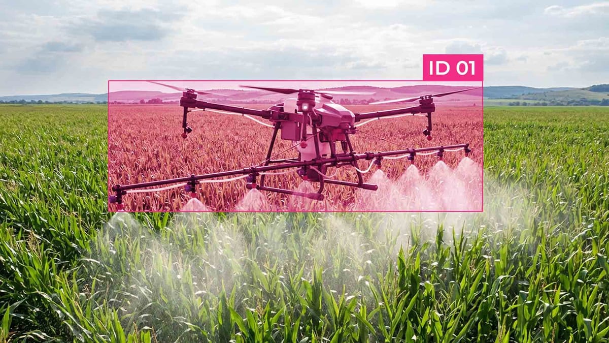
Satellite and Drone Data Integration in Precision Agriculture
- Collecting data from satellites. Satellite images offer extensive coverage of territories and enable the tracking of changes in crop conditions throughout the season. Regular images allow us to see the overall dynamics of crop development and identify potential deviations at an early stage.
- Obtaining highly detailed information from drones. Drone photography complements satellite data with accurate, high-resolution maps. This enables a detailed examination of the areas where the satellite has detected problems and an assessment of the situation at the level of individual plants or rows.
- Combining multi-layered data. Integrating data from various sources creates a comprehensive picture of the field's current state. The combination of large-scale satellite monitoring and local detail from drones enables more accurate identification of stress zones, yield differences, and fertilizer needs.
- Improving analytics with AI. Artificial intelligence algorithms analyze numerous indicators, find patterns, and predict the development of the situation. This enables farmers to make informed decisions based on real data, rather than assumptions.
- Creating task maps for machinery. Integrated data is used to create accurate maps of differentiated fertilizer application, protection products, or irrigation regulation. This allows us to optimize costs and reduce environmental impact.
- Improving operational efficiency. By combining satellite and drone data, farmers can plan operations more accurately, respond quickly to changes, and use resources with maximum efficiency.
- Continuously improving models. With each season, accumulated data enriches analytics and improves forecast accuracy, ensuring the continuous development of the precision farming system.
Remote Sensing Technologies
Remote sensing technologies enable farmers to obtain objective and spatially accurate data on field conditions using satellite platforms, drones, and multispectral sensors. These tools enable monitoring key parameters of crop development, from the density and uniformity of seedlings to signs of water or nutrient stress. By working in different spectral ranges, detailed information is generated that enhances the crop monitoring process, allowing for a deeper understanding of the dynamics of changes throughout the season.
The obtained data become the basis for analytical models that assess plant productivity and its potential in given conditions. Spatial indicators of crop condition are integrated with historical observations, forming the basis for more accurate yield prediction. This enables agricultural enterprises to plan the load on machinery, allocate resources, manage harvesting logistics, and predict economic outcomes.
Optimizing Field Surveillance
Field surveillance optimization involves utilizing data from various sources to develop a system that provides real-time control over crop conditions. The combination of satellite and drone images allows tracking not only general trends in crop growth but also identifies local problem areas where urgent intervention is required. Such surveillance management significantly reduces response time to changes, increases the effectiveness of agrotechnical measures, and enables more accurate prioritization of work in the field.
The integration of the obtained data into digital platforms enables the automation of crop monitoring, producing detailed maps of the vegetation's state and identifying areas with an increased risk of diseases or nutrient deficiencies. These maps serve as the basis for yield forecasting, as the combination of historical data with modern observations enhances the accuracy of yield prediction. In addition, optimized drone and sensor routes enable more efficient resource utilization, reducing the cost of processing large areas and increasing the economic return on the field.
Enhancing Crop Yields and Sustainability
Increasing the productivity and sustainability of agriculture is now increasingly based on the use of accurate data from remote sensing and big data analytics. Tracking crop development in real-time allows not only to identify problem areas, but also to predict their potential throughout the season, which makes it possible to plan fertilizer, irrigation, and plant protection more accurately.
Crop monitoring systems enable farmers to assess the condition of plants at various stages of growth and respond promptly to stress factors, such as pests, diseases, or nutrient deficiencies. As a result, farm efficiency increases, and thanks to yield predictions, it becomes possible to plan production and logistics with accuracy.
Thanks to this approach, agricultural producers can simultaneously achieve two goals: maximize crop productivity and reduce resource costs, which contributes to the long-term sustainability of agriculture.
Resource Optimization Strategies
Sustainable Farming Practices
- Use of organic fertilizers and cover crops. The use of compost, green manures, and other organic materials helps improve soil structure, retain moisture, and increase fertility without excessive chemical use. This also contributes to the health of the field ecosystem and reduces the negative impact on the environment.
- Optimization of water use. The implementation of precision irrigation systems, based on remote sensing data and soil sensors, enables the provision of plants with the exact amount of water they need, thereby avoiding overuse. This helps save resources and reduces the risk of water stress in crops.
- Integrated pest and disease management. The use of drones, satellite images, and crop monitoring algorithms enables the timely detection of local outbreaks of pests or diseases. This enables the application of protective measures on a point-by-point basis, reducing pesticide use and enhancing the environmental sustainability of the farm.
- Crop rotation and diversity. Crop rotation and planting different crops in the same field reduce soil depletion, reduce the risk of disease spread, and contribute to more stable yields.
- Data analytics for forecasting and planning. Using yield prediction algorithms in conjunction with remote sensing data enables more accurate yield forecasting and informed resource planning. This supports sustainable production and optimizes the use of fertilizers, water, and energy.
- Minimal or no-tillage. The use of minimal tillage reduces soil erosion, preserves organic matter, and improves soil structure, thereby increasing long-term field productivity.
Leveraging Data Analytics for Informed Agricultural Decisions
Analytical models offer in-depth crop monitoring, enabling the identification of stress zones, problem areas, and the potential for targeted fertilizer application or plant protection. Based on this data, algorithms predict yield, which helps plan production volumes, logistics, and farm resources. The integration of large data sets from historical and current observations helps optimize management strategies, reduce costs, and increase production resilience to changes in climatic and economic conditions.
Big Data Integration for Yield Forecasting
Thanks to big data, the process of yield forecasting has become more accurate and predictable, which increases farm efficiency, reduces the risk of losses, and promotes the sustainable use of resources.
Integrating big data into the yield forecasting process enables the combination of various sources of information to obtain the most accurate and timely estimates. Data from remote sensing, drones, soil sensors, weather stations, and historical yield records form a comprehensive base that analytical systems use to model crop growth and identify risk factors. This approach enables the real-time assessment of crop potential, taking into account the variability of weather conditions, soil conditions, and plant development dynamics.
Using yield prediction algorithms based on big data helps farmers plan logistics, resources, and marketing strategies more effectively. In addition, analytics help optimize fertilizer application, irrigation, and plant protection measures, as they determine priority zones and expected productivity of each field segment. The integration of such data also enhances crop monitoring, allowing for the tracking of crop conditions in real-time and adjusting agrotechnical solutions long before visual signs of problems appear.
Integration of IoT, Robotics, and AI in Smart Farming
Sensors installed in fields and machinery continuously collect data on soil conditions, moisture, temperature, and crop development, which form the basis for comprehensive crop monitoring. Robotic systems, including autonomous tractor units, drones, and sprayers, use this data to perform agricultural operations with minimal human intervention, ensuring accurate application of fertilizers, irrigation, and plant protection products.
AI analyzes large amounts of information from various sources, predicts crop development, and enhances yield prediction accuracy. Algorithms determine priority areas for processing, assess the effectiveness of agricultural measures, and optimize farm resources to maximize efficiency. The combination of IoT, robotics, and AI enables not only cost reduction and yield increase but also enhances the resilience of agriculture to climate change and unpredictable factors.
FAQ
What is the role of remote sensing in modern agriculture?
Remote sensing provides spatially accurate data on crop health, soil conditions, and environmental factors. It supports crop monitoring and enables timely interventions to maintain productivity.
How do drones complement satellite data in precision farming?
Drones provide high-resolution, localized images that refine the broader view from satellites. This combination enhances crop monitoring and improves the accuracy of detecting stress areas.
What is the significance of crop monitoring for farmers?
Crop monitoring allows farmers to track plant growth, identify stress factors, and optimize resource use. It ensures timely decisions that improve yield and sustainability.
How does yield prediction benefit agricultural management?
Yield prediction models forecast crop performance based on current and historical data. This helps farmers plan logistics, resource allocation, and market strategies effectively.
What technologies are involved in smart farming?
Smart farming integrates IoT, robotics, AI, and remote sensing. These technologies enable automated crop monitoring, precise interventions, and accurate yield prediction.
How do remote sensing technologies enhance sustainability?
By providing detailed insights into field conditions, remote sensing enables precise management of water, fertilizers, and pesticides. This reduces waste, improves efficiency, and promotes sustainable practices.
What is the importance of big data in yield forecasting?
Big data integrates diverse sources, including satellite images, drone data, and sensor readings. This enhances yield prediction accuracy and informs resource optimization strategies.
How does data analytics improve decision-making in agriculture?
Data analytics processes information from remote sensing, IoT devices, and historical records. It provides actionable insights for crop monitoring, risk assessment, and yield prediction.
What are resource optimization strategies in precision farming?
Strategies include variable-rate fertilization, irrigation optimization, and targeted crop protection. They rely on crop monitoring and remote sensing to reduce inputs while maximizing output.
How does the integration of AI and robotics support precision agriculture?
AI analyzes complex datasets to guide autonomous robots and drones for field operations. This improves crop monitoring, enables precise interventions, and enhances yield prediction efficiency.


Comments ()